In late June, two strong seismic events occurred in Japan, causing damage and noticeable consequences.
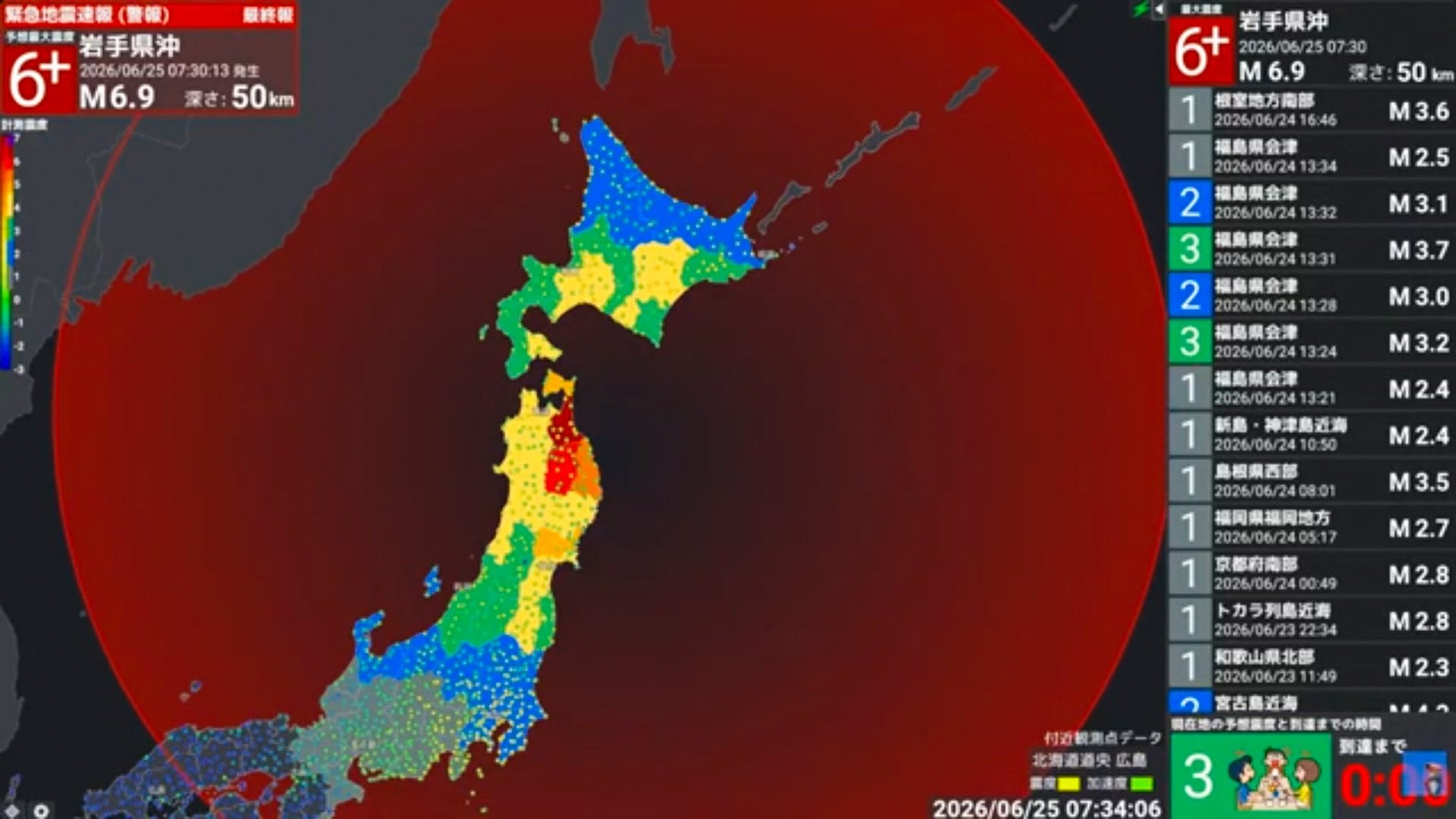
The first earthquake, with a magnitude of 7.2, occurred on June 25 at 7:30 in the morning local time, during the morning rush hour. The epicenter was located off the coast of Iwate Prefecture, about 19 miles from the city of Kuji, and the focus lay at a depth of about 31 miles.
The tremors were accompanied by prolonged ground shaking and were felt across a large area. Seismic waves reached not only the Tohoku region but also the capital, Tokyo. No tsunami threat was generated after this earthquake.
The strongest shaking was recorded in Aomori Prefecture. In the town of Hashikami, the intensity reached level 6+ on the Japan Meteorological Agency scale. This scale describes the strength of ground motion at a specific location, so the maximum intensity may be recorded not strictly near the epicenter, but in the place where the combination of distance, focal depth, and geological conditions amplifies the impact of seismic waves.
The main event was followed by a series of aftershocks. Within three and a half hours, at least 8 aftershocks were recorded, with magnitudes ranging from 2.9 to 4.0.
The consequences of the earthquake affected two prefectures: Aomori and Iwate. In Aomori, more than 360 buildings were damaged; in Iwate, 17 structures were damaged, including schools and social welfare facilities.
In Hachinohe, an elevator stopped in one of the buildings, and a person had to be rescued from it. In supermarkets, thousands of items fell from the shelves, and the floors were covered with shards of broken glass containers.
Damage was also recorded at public facilities. At Kannonji Temple, memorial tablets collapsed. In a nursing home, windows were shattered by the tremors, and cracks that appeared in the walls made the building unsafe for people to remain inside.
Facilities belonging to the Vanraure Hachinohe football club were also affected: walls partially collapsed in the office and on the futsal court. Deep cracks appeared at the Choju Onsen thermal complex.
In total, twelve people were injured. In the city of Kamaishi, Iwate Prefecture, a ninety-year-old woman fell during the tremors and broke her arm. In Hachinohe, Aomori Prefecture, a teenage girl was riding a bicycle, lost control during the shaking, and was hit by a car.
By the evening of the next day, June 26, at 10:29 in the evening local time, another strong earthquake occurred, this time in the eastern part of Yamanashi Prefecture, in the Fuji Five Lakes area. Its magnitude was 5.6, and the focus was located at a depth of about 12 miles.
Despite its smaller magnitude compared with the event off the coast of Iwate, this earthquake also caused strong shaking at the surface. In the town of Fujikawaguchiko, the maximum intensity reached level 6- on the Japan Meteorological Agency scale. This was related to the shallower depth of the focus and its location beneath land: at a smaller depth, seismic waves travel a shorter distance to the surface and can cause sharp local shaking.
According to the Fire and Disaster Management Agency, 15 people were injured.
For Yamanashi Prefecture, this event was especially significant: an earthquake of this strength had been recorded here for the first time since 1924
Damage was reported in several communities. In the city of Kofu, part of the exterior wall of a building collapsed. In Fujiyoshida, concrete walls and roadside signs were damaged. At one hotel in the town of Fujikawaguchiko, elevators stopped working after the earthquake.
One of the region’s most important historical and religious sites, the Kitaguchi Hongu Fuji Sengen Shinto shrine, was also damaged. Its history goes back more than 1900 years, and the complex itself is part of a UNESCO World Heritage Site. As a result of the tremors, 11 stone lanterns about three centuries old were damaged.
The consequences were also felt in neighboring Shizuoka Prefecture. Numerous rockfalls, landslides, and fallen trees were recorded there. Roof tiles fell from buildings, damaging parked cars.
In the town of Oyama, a slope about 66 feet high and about 16 feet wide collapsed behind one of the houses. The situation was complicated by heavy rains associated with an approaching typhoon, so specialists carried out emergency work to reinforce the slope in order to reduce the risk of another ground collapse.
As climate and geodynamic processes continue to change, understanding local risks can be useful for everyday safety.
Today, it is increasingly important to know the specific features of one’s own area: which threats are most likely there, where vulnerable zones are located, how the warning system works, and what to do in the first minutes of a dangerous situation. This kind of awareness helps people avoid panic and act faster, more calmly, and more safely.
Publication of this material provides an opportunity for open discussion and does not in itself imply institutional endorsement, confirmation, or scientific verification of the views expressed. The material does not constitute an official statement, expert opinion, or professional advice.